John Cooke of Union Street, Stonehouse (1823-1845)

Fig. 35. Print of the Royal Hotel and Plymouth Theatre.
Apart
from his maps and charts, not many other engraved works by Cooke have been discovered.
Besides the dedication and the heraldic arms for Gilbert already mentioned, Somers
Cocks[1] lists
a J Cooke for only two topographical prints; the first is of the Royal Hotel and Plymouth Theatre designed
by John Foulston and completed 1818 (80 x 310 mm). This was published and sold
separately, has Cooke´s address as 48 Union Street (Mrs Nile’s address) and is
tentatively dated to 1820 (Fig. 35),
although according to a newspaper advertisement John Whitten took over management
of the hotel in August 1817.[2]
In 1810 Foulston won a competition to design
the hotel and theatre. He moved to Plymouth and went on to design and construct
many more important buildings. The Royal Hotel and Theatre building, and the neighbouring
Athenaeum, were completed circa 1818.
The second entry in Somers Cocks - Cooke, - (lith) - refers to one illustration in Sanford’s editions of The Tourist’s Companion already mentioned. This particular edition appeared in 1828 and 1830[3] and included a small engraving of Stoke Church, Devonport. The signatures are A. Rae delt and Cooke Stonehouse (Fig. 36). Stoke Church is often given special inclusion in his plans and is actually drawn in on some.
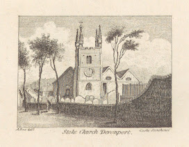

Fig. 36. Stoke Church: From Cooke´s Plan
of 1821 (left); and from editions of The
Stranger’s Guide (right).
Between these two engravings Cooke was engaged to produce four plates for William Welch of Stonehouse. Religiosa Philosophia was the presentation of a New Theory of the Earth in unison with the Mosaic account of creation and appeared in 1821 with an Improved Edition in 1822 (Figs. 37 and 38).[4] Printed for the Author by W Byers, Fore Street, Plymouth-Dock the first edition was to be sold by G and W B Whittaker in London but also by local booksellers such as Curtis, Rowes, Bond and May all in Plymouth and Dyer, Cullum, and Besley in Exeter. The second edition was improved with the inclusion of An Essay on Magnetic Influence and the Variation of the Needle (a subject omitted in Cooke´s Synopsis) and sold by Longman and Co., and by Whittaker and Co., London.

Fig. 37. Diagram of a fossil for W Welch´s Religiosa Philosophia, 1821.
In its 133 pages Welch tried to match the fossil findings of the day with the story of the Bible, but rejected the idea of one great flood being responsible. As almost all the fossil reports he had to go on, were of marine life, he was convinced that the Earth had been covered by water at one time and this had receded when God commanded: And God said, Let the waters be gathered together into one place, and let the dry land appear. And it was so, and God called the dry land EARTH, and the gathering together of the waters, called he SEAS.

Fig. 38. The Firmament for W Welch´s Religiosa Philosophia, 1821.
Reports of marine fossils date back to very
early times, writers such as Xenophanes (570-480 BC), Herodotus (484-425 BC) and
Erathostenes (276-194 BC) all believed land had been under water at one time. At
about the time that Welch began formulating his theory, Georges Cuvier had consolidated
his theories and wrote Recherches sur les ossements fossils de quadrupeds
(1812) and lay the foundations of palaeontology, a word which was first coined
in 1822 by Henri Marie Ducrotay de Blainville.
One of the four plates Welch engaged John
Cooke to execute was an attractive frontispiece – And God made the Firmament
.. – with signature Aqua Tint by John Cooke, Stonehouse. This is one
of only a handful of known aquatints by Cooke. The slim volume also had two plates
of fossils and one further cross-section of 2 mines and the Giant´s Causeway
(each plate approx. 200 x 120 mm). There were over 140 subscribers to this work,
one being Cook, Mr John, Stonehouse [sic].
In December 1825, a curious single page broadside
was published by John Cooke from 48 Union Street. This was a page of text,
illustrated with an engraving showing a balloon landing in the sea between
Stokehead and Yealm Point, near Plymouth, Devon. George and Margaret Graham, well-known
and accomplished balloonists, were no strangers to Devon when they made a tour
of the westcountry in 1825. An advertising announcement in the Alfred of
August 31st the previous year apologises for failed ascents by Mr Graham in Exeter
the previous Tuesday and also in Taunton shortly before and promising to fly
his balloon in Exeter on 7th September of that year. One third of receipts were
to go to the Royal Devon and Exeter Hospital (Fig. 39).
On
their tour of the west country in 1825 they stopped in Plymouth where they
attempted a balloon ascent from Stonehouse market in Plymouth on Monday 14th November.
A series of pilot balloons released prior to the ascent were all carried out to
sea by a strong southerly wind, but nevertheless, the couple set off at 3pm in
front of a crowd of 50,000. Sure enough, the balloon was dragged seaward by the
wind and came down in the sea only 14 minutes later. After 25 minutes the couple
were rescued by a Royal Marine boat and returned to shore. According to some
reports, the balloon was lost, last seen rising from the waters and sailing out
to France never to be seen again, others write about it being rescued by
marines.
The typescript of the broadsheet (Fig. 40) may have been written by the Grahams themselves. Although printed by J Congdon of 28, Fore Street, Devonport, the imprint below the engraving is Cooke´s together with price of 1s and extra line below: with The Description by Mr & Mrs Graham.
.JPG)
Fig. 39. Announcement in The Alfred, August 21st 1824.

Fig. 40. George and Margaret Graham´s balloon mishap
between Stokehead and Yealm Point, Monday 14th November 1825[5].
Although
no more engravings are extant, a number of other maps are known. The Panorama of Plymouth written by
Samuel Rowe contained a Map Of The Country Twelve Miles Round Plymouth
(29). In October 1824
Cooke’s Chart of Plymouth Sound, and General
Guide to Plymouth, Devonport and Stonehouse appeared (31) and Cooke is once again late
engraver to the Admiralty. This map bears a dedication: Under the Patronage of the Chamber of Commerce,
Plymouth.
When one compares this 1824 map to the Chart
... Taken 1817 one is again struck by the similarities. There are numerous
aids to mariners such as copious soundings in every navigable channel, sight
lines to aid vessels on their way in, all buoys are clearly marked, and Tor House
is not only shown but also has its own vignette (Fig. 41). This would
have been clearly visible out to sea and would assist a Captain in their approach.
Perhaps
John Cooke’s most republished map was The
Environs Of Plymouth Devonport And Stone House (33). The map was actually
completed on 4 copper plates but was assembled to form one map and this
appeared with the sub-title A Companion
to the Different Guides of the Neighbourhood published in Stonehouse by
John Cooke circa 1828, it was republished on one sheet and was even
reissued by William Wood of Devonport from circa 1850 in various publications including
issues of his Three Towns Almanack and his Rambles about Plymouth
and Devonport. It even appeared three times in The Three Towns´ Almanack,
a popular annual publication (1861, 1865 and 1868).
Cooke
attempted to receive patronage for this map in the same way he had obtained it
in 1824. In a letter to the Mayor of Plymouth, dated September 1828 Cooke appeals
for support:
To
the Chief Magistrate I take the liberty to send you one of my Proposals, at the
same time beg to ask the favor of your name, and patronage of the commonalty to
be printed on the upper part of it being the wish of several gentlemen of the
corporation, in consequence of which I have drawn up the enclosed proposal for
your inspection and will be happy of the Honor of your acquesience to the same,
as the price of my subscription must be considered moderate, depending on the greater
number to pay the expence, will be happy of the Name of any Gentlemen who may honor
me in addition to those highly respected Gentlemen who have placed their names
on my list.
Signed by Cooke, the handwritten letter accompanied a sheet of proposals for a map that will be engraved on four Plates, to adjoin each other, either to be fitted up as one, or formed into pages for the Pocket or otherwise. It is not clear whether Cooke received the desired effect; the only copy known in four sheets has no dedication but the proposals are Under the Patronage of the Mayor and Commonalty.[6]
.JPG)
Fig. 41. Tor House as shown on Cooke´s Chart of Plymouth Sound.
The
Lord Mayor would have been Capt. R Pridham who was Lord Mayor 1827-28. According
to the Naval Biographical Dictionary he was a prisoner of war in France for ten
years and then on 23 Sept. 1829, in a severe gale off the Cape of Good
Hope, his left arm was broken and his wrist dislocated by a fall on the deck
at midnight; and he also experienced severe injury in the head.[7] According to the Plymouth
Herald of May 1828, Plymouth’s mayor,
Richard Pridham summoned an anti-slavery meeting on 23 May 1828, which was ‘more
numerously and respectably attended than any public assembly ... witnessed for a
considerable time’, with ‘a number of ladies being present’.[8] In 1831 Plymouth had 192 voters of
whom only 146 exercised their right to vote in the elections of that year.[9]
Cooke's Stranger's Guide and Pocket Plan of the Three Towns of Plymouth, Devonport
and Stonehouse (32) was published
in The Traveller’s Directory, and Stranger's
Guide to the Three Towns. The map is embellished with coats of arms of the
towns and is dated 1827. This work also includes an updated version of the breakwater
plan, Cookes Plymouth Breakwater (now
at 82, Union Street). Both maps are
priced individually, indicating sale as single sheets but the title page of the
Directory, however, specifically states
that two engravings are included.
The timing of this edition was not arbitrary. We know there was a royal visit to Plymouth and the breakwater: there is a commemorative stone on the breakwater to Prince Wm. Henry, Duke of Clarence, Duchess of Clarence, July 17th 1827. The Traveller’s Directory was published in 1828 and is important for one more reason: on the title page John Cooke refers to himself as Map & Chart Engraver, and Geographer Extraordinary to H.R.H. The Duke of Clarence, Lord High Admiral.
Subsequent
to 1827 only three more works are known: Cooke's
New Plan Of The Three Towns (34);
a map of Dartmoor (35); and another
breakwater plan in 1843 (36). The New Plan is an up-to-date map of the city
and is dated 1834; the second map, A Map Of
The Whole Of The Dartmoor Forest Devon, although very detailed is undated. The engraver´s signature is extremely
pertinent: By John Cooke, Engraver and Geographer
Extraordinary to his late Majesty in the 75th year of Age. This testifies
to John Cooke´s longevity and reveals that he was still capable of engraving. If
born 1765 he would have produced this map in 1840.
Cooke’s
last breakwater plan (35) is the
most detailed and is interesting for two reasons. Firstly, it is larger than any
other plan with, as before, the two plans: the upper plan has title Cooke’s Plymouth Breakwater, and signature; the lower plan, Transverse Section Of The Breakwater.
Secondly, it is the bye-line below Cooke’s signature and address that is remarkable
- Map & Chart Engraver and Geographer
Extraordinary to His late Majesty William IVth – in his 80th
year of age.
Why
there was a need for a new map of the breakwater in 1843 is uncertain, but it
might have something to do with the new lighthouse. This was being built and would,
in fact, be officially opened on 1st May, 1844 (it is clearly shown
in the plan). To celebrate its formal opening, a postal coach was shipped out and
spent the afternoon of July 23rd transporting passengers up and down
the breakwater.
So
far, we have no evidence that his wife worked and certainly none identifying her
as an engraver. What we have are two documents which point to John marrying
again. and two causing us some doubt! On the one hand, there is a marriage entry
for 4th March 1834 between John Cooke, listed both as sojourner and
as widower, and Elizabeth Nile, sojourner of this parish – St Budeaux. The
marriage was witnessed by Richard Nile and Ann Williams. The term sojourner
is believed to mean they were not local. From the entry in the 1841 census report
we know that John Cooke was resident in Union Lane (sic), East Stonehouse and
still registered as engraver in that year. His age is given as 70 (but rounding
up and down for census reports is known) and his family comprised Eliza Cooke,
50, also an engraver and John (20) and
Charles Cooke (12), both chair-makers. The records show that while John junior
and Charles were born in Devon, Eliza and John were not. It is tantalizing to
think that if Elizabeth/ Eliza was also entered as engraver, could this be the
previous Mrs Nile?
Five
years after completing his last chart, John Cooke died at the age of 80 of apoplexy
on the 11th March, 1845. John’s death was witnessed by a neighbour, Anne
Beer, and not by his wife (Fig. 42). In the 1851 census Elizabeth Nile
is registered as a widow, resident in Egg Buckland. Although only a few miles apart,
St Budeaux and Egg Buckland are not in Stonehouse; the three places form something
of a triangle with sides approximately 5 miles long.
Links to sections of I - London
John Cooke of Howland Street (1799-1805)
The Ladies Circular Atlas and “Mr Barrow”
The Rev. Thomas Smith & The Universal Atlas
John Cooke and the Admiralty (1802-1805)
Between the Admiralty and Plymouth (1805-1812)


No comments:
Post a Comment